Index River Severn Sharpness Canal Severn Estuary Bristol Channel Tides Skipper's Reference Ports of Call Canal Boats Severn Links

  Severn boating  


  Sharpness Canal  

The Gloucester and Sharpness Canal was built to by-pass the treacherous tidal stretch of the River Severn below Gloucester.

At a higher level than the River, the canal is entered via the sea lock at Sharpness or by locking up from the Severn at Gloucester.

It is still a commercial waterway but it is now mainly used by pleasure boats.

It can accomodate vesels upto 240 ft in length and 30 ft beam.

Boats require a licence obtainable from Canal & River Trust for cruising on the canal.  Restrictions to navigation occur during the winter period.

severn-boating map Gloucester and Sharpness Canal

Sea Lock Sharpness The sea lock at Sharpness - entrance from the sea into the Sharpness Canal.

At the time of its completion in 1827 it was the largest and deepest Ship canal in the world.

Part of the canal at Netheridge was re-aligned along a new excavated channel in 2006.


The entrance to the Gloucester & Sharpness Canal from the River Severn.

The narrrow lock entrance is on the left.  The channel on the right leads toward Llanthony weir.

There is often, especially on an ebb tide, a strong current across the lock entrance pulling you towards the weir.

approach gloucester lock from severn

King Arthur

A familiar site in Gloucester Docks and on the Sharpness canal is the excursion boat the 'King Arthur'.

There are several other cruise and excursion boats working the canal.


 Navigation 

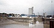
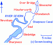
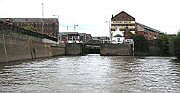
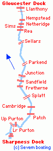
The wide ship canal is some 14 nautical miles long and is punctuated by many swing and 1 bascule bridge.  The bridges are manned, or operated by cctv, and are controlled by traffic lights on the bank; there are plans to make some bridges user operated.

There are few problems for navigation but because of the exposed site of the canal, strong and gusty winds pose a common hazard.

Thick accumulations of water weed may be encountered in summer, often concentrated in the southern section of the canal.

The canal traverses remote and pleasant countryside and offers views of the Severn Estuary , the Cotswolds and the distant hills of Wales.  A number of canal side pubs are easily accessible.

Junction (Saul) bridge marks the crossing of the disused Stroudwater (Cotswold) canal that once linked the Severn and the Thames. There are plans to re open this link.

The wildlife center at Slimbridge is only a short walk from the bridge at Patch.

Several vantage points to view the Severn Bore are within walking distance from the Sharpness Canal.

Sharpness canal bridge map


 Visitor Moorings 

There are designated Canal & River Trust short term visitor moorings in Gloucester Docks, adjacent to Sellars, Fretherne and Patch bridges and opposite to the entrance to Sharpness Docks.

Marinas are located at Gloucester, near Saul and at the southern end of the canal.


 Access to the Sea 

Access to Sharpness Docks is only permitted for boats going to or coming from the Severn Estuary and Bristol Channel.

Booking of the canal entry swing bridge(s) and the sea lock will be required.

Sharpness Dock tidal basinEntering the outer tidal basin from the lock at Sharpness Docks

Low powered craft will wait in this basin for the turn of the tide in the Severn estuary and take the ebb to Avonmouth or beyond.

The sea lock at Sharpness is heavily tide dependant and is available for only a very restricted time period around high tide.

Skippers intending to go to sea should always seek authoritative local advice.


Index River Severn Sharpness Canal Severn Estuary Bristol Channel Tides Skipper's Reference Ports of Call Canal Boats Severn Links

boat home